

Adventures into the Clouds
Our goal at cloudhiking is to help you get outdoors. We try hard to give the most current information for each adventure. If you need more information, we might have an answer, just ask!
Each Adventure Guide is written to entice you to get out there. When we look at the pictures, it makes us want to re-hike the trail or re-ride the greenways. When we look at the maps, we dream of the areas. We hope the Guides do the same for you.
News ...
Finally, a new map! Recently we visited Chickasaw State Park, Savage Gulf (re-hiked to confirm data on Collins Rim Trail), and Bledsoe Creek. The data obtained from the Chickasaw trip was used to make a new map and guide of the area. The trips to Savage Gulf and Bledsoe Creek were just to update current maps.
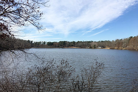
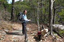
Chickasaw State Park is a great destination. South of Jackson, TN, the Park is nested within the boundaries of Chickasaw State Forest. There are old CCC buildings and structures, great trails around Lake Placid, camping, cabins, and a restaurant. It's worth a visit!
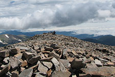
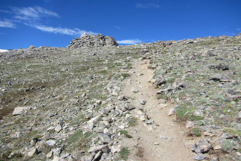
The Mount Audubon (Indian Peaks Wilderness - Colorado) Trail Map is complete and posted. Audubon is a fun 13,000 feet mountain with easy access. It is a great acclimating hike.
A revised Cummins Falls State Park Trail Map has been posted. Cummins Falls is located near Cookeville, TN.
We have not posted new maps or guides to the site in a while. Sorry, but it is not because we are not working on new maps. We are working on a major product that is taking most of our map creation time from us. You will be hearing more about the new maps soon. Thanks for your support.
We have added a couple of new pages (links) to the Virgin Falls Trail pages. By request, we added a description only (no photos) guide to the area (the text is unchanged) and also provided a geo-spatial pdf map for Virgin Falls. The map file may be loaded into a smart phone with a geo-pdf reader, such as Avenza PDF. Virgin Falls is a great Natural Area near Sparta, TN. It is a must see.
New Maps or Guides
Lake Placid
(01/20/16) Chickasaw State Park Guide and Trail Map - Chickasaw is located south of Jackson, TN on Hwy 100. The Park has over six miles of trails which form over 7.5 miles of hiking (some sections have to be walked twice - out and back, other sections are walked more than once to make loops). A guide and geo-pdf map are included.
Audubon's Summit
(08/15/15) Mount Audubon Trail Map - Indian Peaks Wilderness, Roosevelt National Forest, Colorado. At 13,223 feet Audubon stands alone on the eastern edge of the Indian Peaks. There are great views of the Continental Divide to the west and Rocky Mountain National Park (including Longs Peak) to the north. The trail is mostly Class 1 with a bit of Class 2 on the final stretch leading to the summit. The trail is dog friendly, but dogs must be on a leash at all times.
(07/14/15) Cummins Falls State Park Trail Map - Tennessee State Park (the link is to the Cummins Falls page, the map links are on Page 2). A great, small, State Park with the reputation as having one of the best swimming holes. The map is revised to include the Upstream Trail and options for either the PDF or Geo-PDF maps.
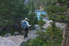
Taylor Peak from Sky Pond
(04/16/15) Guide to The Loch, Glass Lake, and Sky Pond - Rocky Mountain National Park. The map was competed last month and finally, we were able to finish the guide. Enjoy the guide and plan for a hike!
View of Longs and Meeker from East Deer Mountain Trail
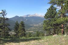
(04/02/15) Deer Mountain - Rocky Mountain National Park - (map only) - updated Deer Mountain Trail Map to include the North Deer Mountain Trail, East Deer Mountain Trail, South Deer Mountain Trail, plus other trails to the north and south of Deer, and the standard Deer Mountain Trail.
On the North Rim Trail
(03/23/15) Savage Gulf Trail Map - South Cumberland State Park - (map only) - 3rd update to Savage Gulf, specifically the North Rim Trail from Savage Gulf Trailhead, Hobbs Cabin area, and the North Plateau Trail. We only have one Savage Gulf Trail Map, the updated map has all of the corrections - see below (02/06/15) and (02/19/15)
Trail Approaching Mills Lake
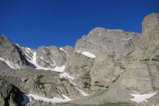
(03/09/15) Glacier Gorge - Sky Pond Trail Map - Rocky Mountain National Park - (map only) - Trail map of Glacier Gorge Trailhead trails. Map includes Glacier Gorge, Sky Pond, Andrews Glacier, Black Lake, Mills Lake, The Loch, Glass Lake, Lake Haiyaha, Emerald Lake, Dream Lake and more ... A great map for the popular eastern-central section of Rocky Mountain National Park.
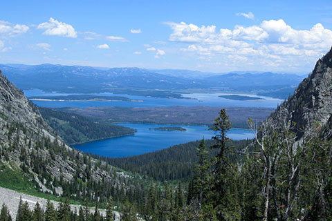
View of Leigh and Jackson Lake from Paintbrush Canyon
(03/01/15) Paintbrush Divide Loop Trail - Guide to a great tour of Grand Teton National Park. The 18.85 mile loop climbs Paintbrush Canyon and descends the North Fork of Cascade Canyon to Cascade Canyon and then closes the loop with a short walk along Jenny Lake.
(02/19/15) Savage Gulf Trail Map - South Cumberland State Park - (map only) - 2nd update to Savage Gulf, specifically the South Rim Trail from Savage Gulf Trailhead. We only have one Savage Gulf Trail Map, the updated map has all of the corrections - see below (02/06/15).
Mount Yale from Princeton
(02/09/15) Mount Yale Trail - Trail Guide to the Southwest Slopes route on Mount Yale. It is the standard route on Mount Yale.
(02/06/15) Savage Gulf Trail Map - South Cumberland State Park - (map only) update for the Map of Savage Gulf Natural Area, a premier hiking destination. The update is only for about 9 miles of trail, Greeter Trail (from Alum Gap to Boardtree Falls, Laurel Trail, Big Creek Rim, Stone Door Trail. We only have one Savage Gulf Trail Map, the updated map has all of the corrections - see above (02/19/15).
Approaching the 13,900' Saddle on Massive
(02/03/15) Mount Massive Trail - Trail Guide to the East Slopes route on Mount Massive. The route is the standard for Mount Massive. It is a Class 2, classic.
(01/30/15) Mount Yale Map - (map only) - Chaffee County, Colorado, Sawatch Range. Mount Yale is one of the Collegiate Peaks. Located west of Buena Vista, CO, Yale is popular due to the easy (paved) trailhead access, improved trail (thanks CFI), and a great upper slope and ridge. Yale is a great hike, we hope the map is well used!
(01/27/15) Mount Massive Map - (map only) - Lake County, Colorado, Sawatch Range. Mount Massive sits a few miles north of Mount Elbert (the highest summit in Colorado) but Massive looks bigger. Massive is so huge, it dominates the view from nearby Leadville. The mountain begs you to climb it. Enjoy the map, a trail guide is soon to come!
(01/20/15) Pogue Creek Canyon Natural Area Map - Tennessee State Natural Areas - Tennessee State Parks - a new trail to the Canyon Overlook and hopefully more trails will be added to the area in the coming years.
(1/11/15) Jenny Lake Trail - Grand Tetons National Park - a great loop route around the iconic lake. Guide includes a sidetrip to Hidden Falls and Inspiration Point. The photos alone are worth a visit.
(12/30/14) Paintbrush Divide Loop Trail - Grand Teton National Park (map only) - the loop hike route that climbs Paintbrush Canyon, crosses the divide, and descends the North Fork of Cascade Canyon and Cascade Canyon to return. Also included are a few popular lake hikes included: Jenny Lake, String Lake, Leigh Lake, Bearpaw, Trapper, Holly Lake, and Lake Solitude.
(12/04/14) Savage Gulf Trail Map - South Cumberland State Park - (map only) Map for the Savage Gulf Natural Area, a premier hiking destination. The map is not complete. We have not recorded all of the necessary trail data, but plan to be adding to the map over the winter months. On trails where we did not have GPS track logs, we used the TDEC GIS Data.
(11/06/14) Onahu Creek - Green Mountain Loop - Rocky Mountain National Park - a 7.60 mile loop route that climbs Onahu Creek to Big Meadow and then returns to the Kawuneeche Valley. The route makes an excellent day hike or overnight trip.
(11/01/14) The Loop - Rocky Mountain National Park - the loop route of the North Inlet Trail and Tonahutu Creek Trail from Grand Lake, CO to the Continental Divide on Flattop Mountain. The route is above treeline for more than seven miles! The Loop is the premier backpacking destination in the Park and is part of the Continental Divide Trail.
(10/26/14) Tonahutu Creek Trail - Rocky Mountain National Park - The route from Grand Lake up Tonahutu Creek to Big Meadow and then east to Granite Falls and Haynach Lake Junction. The route turns at the Haynach Lake Trail and follow it to Haynach Lake. the Tonahutu Lake Trail is the third leg of the Loop.
(10/21/14) North Inlet Trail - Rocky Mountain National Park - The popular route up the North Inlet from Grand Lake. The guide includes Summerland Park, Cascade Falls, Big Pool, Ptarmigan Creek, North Inlet Junction, Lake Nokoni, and Lake Nanita. The trail to North Inlet Junction is the first leg of the Loop.
(10/14/14) The Loop - Rocky Mountain National Park - West (map): the North Inlet and Tonahutu Trails plus Haynach Lake Trail, Lake Nanita Trail, Green Mountain Trail, and Onahu Creek Trail. The must do Loop route in Rocky Mountain National Park.
(09/18/14) LSR - Phelps Lake Trails - Guide - guide to the Grand Teton National Park's popular moderate route that leads from the Preserve's Interpretive Center to Phelps Lake, goes around the lake, and then returns. Great photos!
(09/18/14) LSR Preserve's other Trails - abbreviated guide to the other trails of the Preserve (Aspen Ridge Trail, Boulder Ridge Trail, Connector, Phelps Lake Trail from Lake Creek Trail to Woodland Trail.)
(09/13/14) LSR - Phelps Lake Trails - Map - map to the Laurance S Rockefeller Preserve trails and the Phelps Lake Trail in Grand Teton National Park. Trails starting at the Interpretive Center Trailhead lead to miles of great trails and great views.
(09/03/14) South Mount Elbert Trail - trail guide to the East Ridge Route on Mount Elbert. Check out the North Elbert and South Elbert Trails. We did then together as a 'tour de Elbert.'
(08/26/14) North Mount Elbert Trail - trail guide to the popular route up the Northeast Ridge of Elbert.
(08/20/14) Skills - links to the many skill related pages (and some stories) from our Metro to Mountain Journal. Many series and individual entries. Check it out!
(08/20/14) Mount Elbert - (Map) Over the summer, while staying in Leadville, CO we re-hiked Mount Elbert, Colorado's highest peak. It was a fun hike and now we have the map complete. Enjoy! Oh, the guides will soon follow - we did two trails on the peak.
(05/17/14) Richland Creek Greenway - Metro Nashville Park. We orginally drew the map in 2009, and it needed revisions. The Richland Creek Greenway map is completely re-drawn. Load it onto your smart phone or geo-pdf reader and test it on your next walk, run, ride on this great greenway. We have also updated the Richland Creek Greenway pages (05/22/14)
(05/05/14) Sandbeach Lake - Rocky Mountain National Park. Another Wild Basin Area lake. With close access to the Park Entrance the trail climbs 4.3 miles to the lake. Most of the trail is moderate. The lake has great views of Mount Meeker's southern flanks.
(04/30/14) Finch Lake - Pear Lake in Rocky Mountain National Park. Our first guide to the Wild Basin area of the Park. The lakes are about 4.5 miles and 6.5 miles from the Finch Lake Trailhead on good trails. The lakes are a must see.
(04/16/14) Wild Basin in Rocky Mountain National Park - (map only) the trails of the Wild Basin area of the Park. Many great trails to alpine destinations. We also hope to finish a couple of guides to the area before summer.
(3/28/14) Gregory Ridge Trail to Gregory Bald - From Gregory Ridge Trailhead the trail follows Forge Creek to the campsite and then climbs the ridge to Ridh Gap and the Gregory Bald Trail.
(3/13/14) Wolf Ridge Trail to Gregory Bald - Another guide to Gregory Bald from the Twentymile Trailhead.
(2/17/14) Long Hungry Ridge Trail to Gregory Bald - Guide to Gregory Bald route from the south, Twentymile Trailhead.
(2/7/14) Gregory Bald (map only) - Just uploaded the Gregory Bald Trail Map to Great Smoky Mountain National Park. The guide is soon to come. We also intend to hike the trails from Cades Cove and complete the map this Spring.
Any suggestions are welcome. Thanks for your support.
Happy trails to all, hope to see you on the trails somewhere.
Most Recently Added Guides
Chickasaw State Park - Henderson, TN. Guide to trails of the State Park.
The Loch, Glass Lake, Sky Pond - Rocky Mountain National Park. One of the great mountain lake hikes.
Paintbrush Divide Loop Trail - Grand Teton National Park. The Route includes Paintbrush Canyon, North Fork of Cascade Canyon, and Cascade Canyon.
Mount Yale Trail - Sawatch Range, Colorado - standard route on Mount Yale, 14,196'.
Mount Massive Trail - Sawatch Range, Colorado - the standard route climbing the 14,421' Mount Massive.
Jenny Lake Trail - Grand Teton National Park - the route around the popular lake. Guide includes the route to Hidden Falls and Inspiration Point.
Onahu Creek - Green Mountain Loop - Rocky Mountain National Park - the route follows the beautiful Onahu Creek and then loops around to Big Meadow.
The Loop - Guide - Rocky Mountain National Park - closing the North Inlet Trail and Tonahutu Trail with the above treeline section of this great route.
Tonahutu Creek Trail - Guide - Rocky Mountain National Park - another west side of the Park trail and the third section of the Loop.
North Inlet Trail - Guide - Rocky Mountain National Park - popular west side of the park trail and the first section of the Loop.
LSR - Phelps Lake Trails - Guide - Grand Teton National Park - popular moderate route around Phelps Lake.
LSR Preserve's other Trails - Grand Tetons, guide to the other trails of the Preserve (Aspen Ridge Trail, Boulder Ridge Trail, Connector, Phelps Lake Trail from Lake Creek Trail to Woodland Trail)
South Mount Elbert Trail - Sawatch Range, Colorado, trail guide to the East Ridge Route on Mount Elbert.
North Mount Elbert Trail - Sawatch Range, Colorado, guide to popular route that climbs the Northeast Ridge of Elbert.
Richland Creek Greenway - Nashville, a complete update of Greenway pages
Sandbeach Lake - Wild Basin area of Rocky Mountain National Park
Finch Lake - Pear Lake - Wild Basin area of Rocky Mountain National Park
Gregory Ridge Trail to Gregory Bald - Great Smoky Mountain National Park
Wolf Ridge Trail to Gregory Bald - Great Smoky Mountain National Park
Long Hungry Ridge Trail to Gregory Bald - Great Smoky Mountain National Park
Grand Teton Loop - Grand Teton National Park - WY
Lower Loop - Fall Creek Falls State Park - TN
Lawn Lake - Rocky Mountain National Park - CO
Hallett Peak, Flattop Mountain - Rocy Mountain National Park
Timber Lake - Rocky Mountain National Park - CO
Mount Ida, North Ridge - Rocky Mountain National Park - CO
Hidden Passage - Pickett State Park
Eagle Point Overnight Trail - Mousetail Landing State Park, Linden, TN
Keyhole Route - Rocky Mountain National Park - CO
Deer Mountain Trail - Rocky Mountain National Park - CO
Alum Cave Trail - Great Smoky Mountain Park - Tennessee
Standing Stone Park - Hilham, TN
Amphitheater Lake Trail - Grand Teton National Park - Wyoming
La Luz Trail - Sandia Mountains - New Mexico
Vaughn Creek Cross Country Trail - Warner Parks, Nashville
Pikes Peak - Barr Trail - Colorado Mountains
Cummins Falls State Park - Cookeville, TN
Grays and Torreys - Colorado Mountains
Virgin Falls State Natural Area - Sparta, TN
Lily Lake Trails - Rocky Mountain National Park
Estes Cone Peak - Rocky Mountain National Park
Short Springs State Natural Area - Tullahoma, TN
Twin Sisters Trail - Twin Sisters Peak, Rocky Mountain National Park
Ellington Agricultural Center Trails - Nashville
Wall Trail, Optional Trails - Old Stone Fort State Park
Alternate Trails, Garrison Loop - Old Stone Fort State Park
Patriot Lake Trail - Shelby Farms Park Conservancy
Chickasaw and Greenline Connector Trails - Shelby Farms Park Conservancy
Most Recently Added Maps
Map - Chickasaw State Park Trail Map - Tennessee State Park - geo-pdf map (20JAN16)
Map - Mount Audubon Trail Map - Indian Peaks Wilderness, Roosevelt National Forest, Colorado - geo-pdf map.
Map - Cummins Falls State Park Trail Map - Tennessee State Park (the link is to the Cummins Falls page, the map links are on Page 2) - Revised map and geo-pdf map.
Map - Deer Mountain Trail Map - Rocky Mountain National Park - Trail map to Deer Mountain. The map is a major update to the old Deer Mountain map.
Map - Glacier Gorge - Sky Pond Trail Map - Rocky Mountain National Park Trail - Map for the popular eastern-central section of trails - 09Mar15
Map - Mount Yale Map - Another peak in Colorado's Sawatch Range - 30Jan15
Map - Mount Massive Map - Colorado's Sawatch Range - 27Jan15
Map - Pogue Creek Canyon Natural Area Map - Tennessee State Natural Areas - Tennessee State Parks - 20Jan15
Map - Paintbrush Divide Loop Trail - Grand Tetons National Park (map only) - 30Dec14
Map - Savage Gulf Trails Map - South Cumberland State Park - 04Dec14
Map - The Loop - Rocky Mountain National Park - West side - 14Oct14
Map - LSR and Phelps Lake Trails - Grand Teton National Park - 13Sep14
Map - Mount Elbert, Colorado's Sawatch Range - 20Aug14
Map update - Richland Creek Greenway - 17May14
Map - Wild Basin, Rocky Mountain National Park - 16Apr14
Map - Gregory Bald, GSMNP - Smokies - 10Feb14
Map - Grand Teton Loop - 16Dec13
Map - Mummy Range Rocky Mountain National Park - 12OCT13
Map - Hallett Peak, Flattop Mtn - Rocky Mountain National Park - 02Sep13
Map - Mount Ida - Rocky Mountain National Park - 30May13
Map - Pickett State Park Trails - 09May13
Map - Mousetail Landing Trails - 11APR13
Map - Longs Peak Trails - Rocky Mountain National Park - 18Mar13
Map - Deer Mountain Trail - 17Feb13
Map - Mount Le Conte Trails - 02Feb13
Map - Standing Stone Park - 27Jan13
Map - Amphitheater Lake Trail - 13Dec12
Map Update (new) - Montgomery Bell Park - 03Dec12
Map - Angels Landing (Zion National Park) - 26Nov12
Map Update (new) - Cedars of Lebanon - 11Nov12
Map Update (new) - Beaman Park - 29Oct12
Map - La Luz Trail (New Mexico) - 08Oct12
Map - Vaughn Creek Cross Country Trail - 27Sep12
Map Update (new) - Radnor Lake - 17Sep12
Map Update (new) - Barfield Park - 03Sep12
Map - Barr Trail, Pikes Peak (CO)- 25Aug12
Map - Cummins Falls State Park - 23May12
Map Only - Hallett Peak (RMNP) - 05May12
Map Only - Fall Creek Falls - 12Apr12
Map - Grays and Torreys (CO) - 03Mar12
Map - Virgin Falls - 17Feb12
Map Only - Warner Parks Map - 04Feb12
Map - Estes Cone and Lily Lake (CO) - 27Dec11
Map - Short Springs Natural Area - 01Dec11
Map - Twin Sisters Trail (CO) - 16Nov11
Map - Ellington Agricultural Center - 26Oct11
Map - Old Stone Fort - 07Oct11
Map Only - Upper Loop at Fall Creek Falls - 16June11
Map Only - Alum Cave Trail & the Boulevard - Mount LeConte & Mount Kephart - updated - 15June11
Map - Shelby Farms Park Conservancy - 20May11
Colorado Fourteeners, 2009
For six months we planned the trip and in fifty-three days climbed the fifty-four peaks. It was a great summer adventure. There were things that we did right, things that we did wrong, and things that we just did because it was the next day! By the end of the summer we were fit and ready to climb, but also ready to be home in Tennessee. Thanks to all those who helped us complete our goals as well as all those who shared the experiences with us. We loved it.
The original cloudhiking site chronicling our trip with descriptions of each route is still an important part of this site. If you are interested in doing all or some of the Colorado Fourteeners, it is a must read.
Oh, we have never edited our comments, so the candid remarks are still fresh.