

Hallett Peak - West Slopes & Flattop Mtn, Rocky Mountain National Park
The Adventure Guide to the Flattop Mountain Trail and West Slopes Route of Hallett Peak includes a trail description, photographs of the trails, comments from our hikes, mileage data, custom Hallett Peak topo map, and route GPS tracklogs. The guide will familiarize you with the mountain and help you on your climb.
Photos from: 2007, 2008, 2010, 2011, 2013
Elevation: 12,712 (Flattop Mtn - 12,324)
Range: Rocky Mountain National Park
Bear Lake - Latitude: 40.31197, Longitude: -105.64542
Route: Flattop Mountain Trail & Hallett Peak, West Slopes
One-Way Mileage: 4.40 to Flattop Mtn, 5.10 to Hallett Peak
For Map, Trail Mileage, GPS, and Trail Notes go to Page 2
Pre-Climb Comments
Hallett is a 12,712 feet peak on the Continental Divide in Rocky Mountain National Park. From the popular Bear Lake Trailhead, a good trail leads to Flattop Mountain and then a short 400 foot climb leads to the summit of Hallett. The West Slopes Route of Hallett is a Class 2 climb, it is not a trail. The slope is rocky (some loose) and the slight path might be considered hard to follow. Climbers use stacked rocks, cairns, to help mark the route. Many hikers climb Flattop each day of the summer and quite a few of those who reached Flattop continue to Hallett Peak.
The Climb
Directions: From Estes Park, follow Hwy 36 west to the Beaver Meadows Park Entrance. Turn left on Bear Lake Rd, a short distance beyond the entrance booths. Follow Bear Lake Road (about 9 miles) to the large parking area located at the end of the road. The parking area does fill almost every morning of the summer. A free bus shuttle operates from the Park and Ride (located near Glacier Basin Campground) to Bear Lake Trailhead.

From the developed parking area at 9475 feet, begin the hike by crossing a bridge on the wide path.

Shortly after crossing the bridge the trail comes to a junction. Go right and hike a few hundred feet along the east bank of Bear Lake.

Hoards of visitors stop along the lake to take photos of Hallett Peak. Bear Lake is a satisfying goal for most visitors.

The trails to Flattop Mountain, Fern Lake, and Lake Bierstadt cuts off from the Bear Lake Trail at a well signed junction. A short distance up from the junction is the Flattop Mountain Trail Kiosk. The board contains pertinent information about the trail.
From the kiosk the trail begins the climb. After a short climb, a horse path enters from the right and joins the Flattop Mountain Trail.

Continuing the climb for another .40 mile the trail comes to a junction. The Lake Bierstadt Trail continues straight, and the Flattop Mountain trail goes left. The junction is actually a switchback for the Flattop Mountain Trail. The mileage sign indicates it is .40 mile back to Bear Lake (and another .10 mile to the trailhead/parking area.)

At the Bierstadt Lake Junction, there is also a mileage sign for the Flattop Mountain Trail and the Fern Lake Trail.
From the Bierstadt Lake Junction, the trail climbs steadily to the west. After about .25 mile the trail crosses over the top of a boulderfield. At .50 mile the trail reaches the Fern Lake Trail Junction. The Flattop Mountain Trail tends to the left. The Fern Lake Trail goes right or straight.

Leaving the Fern Lake Junction the trail climbs through a few shorter switchbacks and ten a longer leg. A switchback is just before a boulderfield with great views to the northeast (toward Estes Park.)

Dream Lake Overlook is the next waypoint. It is 1.70 miles from the the overlook to Bear Lake Trailhead. Many folks use the area as a rest stop.

Above Dream Lake Overlook the trail begins to climb through timberline.

The trees and shrubs through the region are stunted and finally disappear as they give way to the alpine tundra.

As the trail continues to climb the 1.30 miles to Emerald Lake Overlook it uses many switchbacks. Nearing the overlook the legs, or distance between the switchbacks, is shorter.
The Emerald Lake Overlook is a great rest stop. It is also a good time to make decisions about the weather.
From the above picture, the technical climbing buttresses are the cliffs of Hallett Peak. The actual summit of Hallett is the peak in the background.

Emerald Lake Overlook is 3.0 miles from the Bear Lake Trailhead. It is 1.40 miles to the top of Flattop Mountain and 2.1 miles to the summit of Hallett Peak. Emerald Lake is 1200 feet below.

Just above the overlook the trail passes the "Mountains Don't Care" plaque. The gist of the message is the mountains are a harsh and potentially dangerous environment in any season. If the conditions do not match the hiker's experience and gear, then it is time for them to turn around and find something fun to do at a lower elevation.

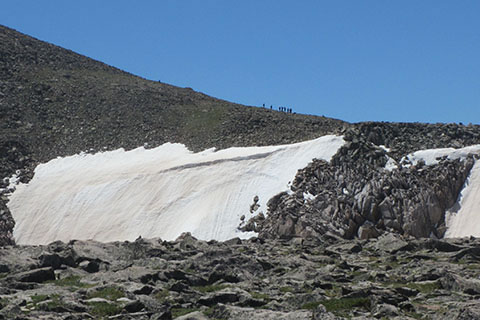
Crossing the alpine tundra, the trail climbs 1.00 mile to another overlook, the hitching post. The well used rest area is 4.00 miles from the trailhead. There are good views of Hallett, if the mountain is not covered in clouds.

Above the hitching post a snowfield is present through July in most years. A worn boot track will lead through the snow. From the top of the snowfield it is an easy walk to the top of Flattop. Most hikers celebrate the summit at the trail sign. It is 4.4 miles from the trailhead.
To continue, Hallett Peak is located to the south or to the left. There is no official trail to Hallett Peak. Instead, follow the climbers path toward the base of the West Slopes of Hallett Peak.

Walking along the approximate path of the Continental Divide, the route crosses the top of the Tyndall Glacier. A warning sign reminds hikers of the steep snow.

The West Slope of Hallett is a rock/boulder strewn slope. Use care in selecting the easiest path. Most of the rocks are loose and will roll. Step lightly.

When the rocky slope hides the path, climbers use stacked rock markers, cairns, to help mark the route. The cairns are made by climbers and are unofficial.

The Hallett West Slope Route is straightforward. The route climbs about 400 feet from the Tyndall Glacier or Saddle (at the danger sign).

The summit is at 12,713 feet. There are a couple of wind breaks and great views in all directions. The summit is about .70 mile from the top of Flattop and 5.1 mile from Bear Lake Trailhead.