Walk 100 Miles with the Mayor
Nashville (and Area) Greenways
As we have traveled walking, hiking, running, and biking the trails and greenways of the state, one thing we are sure of, people like exercising on paved paths. Greenways offer safe, easy to follow paths. The areas greenways make great destinations to Walk 100 Miles with the Mayor.
A few notes ...
If you walk all of the listed paths, your total distance would be 110 miles. (Most of the paths are linear and require an out and back route.)
All mileages are for a round trip walk. Paths could be shortened using two vehicles.
There are still other greenways in Nashville and the neighboring areas. These are just the ones we have done. They are all recommended.
The Greenways
.80 mile - Main Trail - Brookmeade Greenway. A short route that travels .40 mile to the Cumberland River and an observation platform. On both of our visits to the path, we saw walkers doing laps on the trail. (Metro to Mountain Trip Report - near the end of the page)
1.0 mile - One Mile Loop - Centennial Park, Nashville. An interesting path around the Parthenon, Watagua Lake, and other Park attractions. The path is well used. Many users walk laps around the loop. The path is also used for many walking events and fund raisers. We do not have a map or guide to the path. (Metro to Mountain Trip Report)
2.0 miles - Couchville Lake - Long Hunter State Park. The 2 mile loop circles the lake with a few observation decks. A tree guide is available for the path. No dogs are allowed. The path is well used.
2.90 miles - Main Trail - Peeler Park. A lollipop trail in Neeley's Bend. The path follows along the Cumberland River, makes a loop and returns to the trailhead. The Park also features horse trails. (Metro to Mountain Trip Report)
4.30 miles - Downtown Greenway - Cumberland River Greenway. The path begins at Riverfront Park and goes downstream 2.15 miles to the Great Circle Trailhead at the Metro Center. The path weaves through industrial properties and businesses. A side trip to Bi-Centennial State Park adds to the adventure. Path may also be walked in the opposite direction. The path is popular with bicyclist.
4.50 miles - Richland Creek Greenway - McCabe Park. The path follows the boundaries around the McCabe Golf Course. The 4.5 mile loop starts at the Publix trailhead off West End, crosses the creek, loops the Park and then returns. Side trips to increase the mileage go to Lions Head Shopping Center and Tennessee State Technical Institute. The path offers history and scenery.
5.0 miles - Harpeth River Greenway - Edwin Warner Park. Starting at the Woolwine Trailhead the path goes around Ensworth School and follows the Harpeth River to the Exchange Park. The path is 2.5 miles one way. Additional miles may be added by combining the path with the many other paths and trails in Edwin Warner Park.
5.35 miles - Old Roadway - Edwin Warner Park. The Old Roadway in Edwin Warner Park is closed to motor vehicles. The roadway is open to walkers, runners, and bicycles and they use it. The map shows many of the options, but the 5.35 mile course starts at the Natchez Trace Trailhead, follows the Main Loop to the Ridgefield Riverbend, goes to the Little Harpeth and Returns, then detours from the Main Loop to the Scenic Overlook and on to the no longer used Old Hickory Entrances - before it returns to the Main Loop and back to the Natchez Trace Trailhead. There are many options available using the great trails and roads of the Park. The link is to the map. (Metro to Mountain Trip Report)
5.40 miles - Metro Center Levee - Cumberland River Greenway. Starting at Great Circle Trailhead the path follows along the top of the levee 2.70 miles to Freeland Station Trailhead. There are great views of the river and Metro Center - including the Titans training facility. The path is well used. The path has also been extended beyond Freeland Station and around Ted Rhodes Golf Course for over one mile to the clubhouse.
5.8 miles - The Five-Eight - Percy Warner Park. Starting at he Belle Meade entrance to Percy Warner Park the Main Drive dips in and out of hollows, passes Deep Well Trailhead and then climbs 3 Mile Hill. At he top of the hill a signed road junction sends the 5-8 to the left as it returns to the Park Entrance. The 5-8 is a well used walking, running, and biking course. It is also a good alternative when the trails are muddy (not worried about the mud on the shoes, more the added trail erosion.) The roadway is open to motor vehicles.
5.90 miles - Kohls to Percy Priest Dam - Stones River Greenway. A scenic path along the Stones River. The path includes a picturesque raised walkway (boardwalk). Mileages may be increased by a side trip to the YMCA.
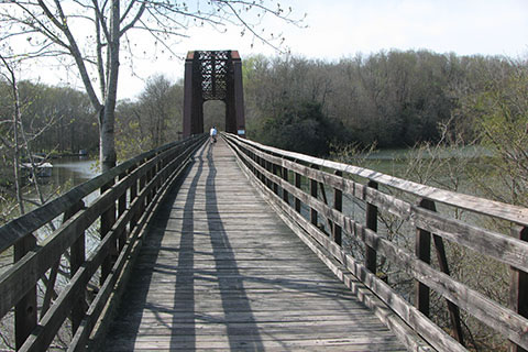
6.80 miles - Shelby Bottoms Trailhead to the Skate Park - Shelby Bottoms Greenway. Starting at the Shelby Bottoms Trailhead the path goes along the Cumberland River. Several side trails go to the other access locations for Shelby Bottoms. After close to 3 miles the Cumberland River Bridge crosses the river. What a great structure that connected the communities on each side of the river. The Skate Park is just a bit further beyond the bridge. The path is well used.
7.85 miles - Shelby Bottoms Trailhead to the East Loop - Shelby Bottoms Greenway. Same as above, but instead of crossing the river on the bridge, continue along the river to the East Loop. After looping return to the trailhead.
8.80 miles - Thompson Lane Trailhead to Cannonsburg Trailhead - Stones River Greenway, Murfreesboro. Murfreesboro has a great greenway system. Starting at Thompson Lane Trailhead, walk south along the Stones River. There are many access points, viewing areas and bridges. The trail does cross a few streets. Continue 4.4 miles to historic Cannonsburg and then return. Side trips may also be made to Gateway Island and Stones River Battlefield. The path is well used. (Metro to Mountain Trip Report)
9.20 miles - Old Fort Trailhead to Barfield Road - Stones River Greenway, Murfreesboro. The Old Fort recreation area is the hub of the Murfreesboro Greenway system. Starting at the trailhead take the path as it weaves through the Park and to the banks of the Stones River. the path follows the Stones River to the Two Forks near Barfield Road. Plans are in the works to continue the path to Barfield Park. (Metro to Mountain Trip Report)
9.80 miles - Skate Park to Kohls - Stones River Greenway. From the Skate Park at Two Rivers Park follow the path as it crosses under Two Rivers Parkway and around McGavock High School. The path then goes under McGavock Pike and down a very steep hill to the Heartland Fields. Cross the Stones River and continue to Lebanon Road. The path follows the Old Lebanon Road across Stones River and then circles under the bridges to the Kohls Trailhead.
11.20 miles - The Eleven-Two - Percy Warner Park. If you thought the 5-8 mile loop was fun, then here's the daddy. Follow the 5-8 to the top of Three Mile Hill and then instead of turning stay on the Main Drive as it loops around the southern part of the Park. The 11-2 goes by the Steeplechase and the Harpeth Hills Golf Course. After passing the Beech Woods area the road climbs Nine Mile Hill. At the junction the 5-8 mile loop joins the Main Drive from the left. Continue to the entrance. The Eleven-Two is the most difficult of all the routes. The roadway is open to motor vehicles. (Map Only)
13.50 miles - Marks Creek Trailhead to Lock A Campground - Bi-Centennial Greenway, Ashland City. There is a great rails-to-trails path in Ashland City. The Bi-Centennial Greenway begins at Marks Creek Trailhead and goes south for 4 miles to Sycamore Creek Trailhead. The path continues 2.75 miles on a hardened gravel surface to the Lock A Campground. Along the path there are excellent views of the Cumberland River. (Metro to Mountain Trip Report)
Total distance - 110.1 miles