

Virgin Falls Natural Area, page 2
Trail Notes
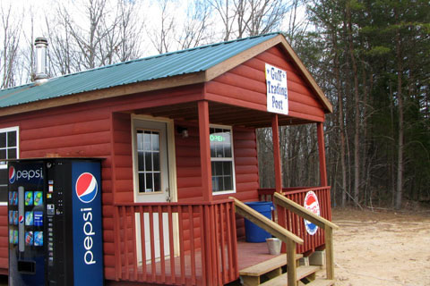
There is a new small store at the junction of Eastland and Savage Gulf roads. We have no ties to the store; but in talking to one of the owners we found that the store was opened for the Virgin Falls hikers.
The parking area at the trailhead is fairly large; but the area sees a lot of traffic.
There are no restrooms or water at the trailhead.
The elevation at the Parking Area is 1750 feet. The lowest point of the trail, just below Virgin Falls near Caney Fork Creek, is 900 feet.
Hiking to Virgin Falls is quite easy; but the hike out is a little tougher as it is all uphill.
When we visited the area, the streams were full. The crossing were not too difficult; but they could be tough with an extra foot of water in their banks.
In the rainy season, some of the low lying areas flood.
When crossing the creek with the cable, stay on the downstream side.
The cable crossing is over Laurel Creek, not Big Branch.
The trail was well marked with freshly painted blazes.
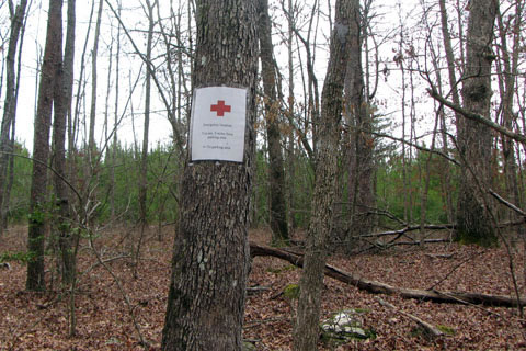
There have been some issues with hikers getting lost in the area. To aid in navigation, temporary signs have been posted every half mile - giving directions. The trail also has new blazes clearly marking the paths.
Mileage Marker
The temporary direction signs are marked with red crosses. They will soon be replaced with more permanent signage.
Remember, Virgin Falls is a Natural Area - in a wilderness setting. Users have to exercise good judgement and common sense to safely visit the area.
There are five campsites in the area - near the Cable Crossing, Martha's Pretty Point (the Overlook), Big Laurel Falls, Virgin Falls, and Caney Fork.
A new camping self registration program began in the Fall of 2013. Please follow the policies as indicated on the trailhead kiosk. Thanks!
When we hiked, there was no litter on the trail, other than at the camping areas.
Never litter. If it does not grow there, pack it out.
Collect only dead and downed firewood for campfires. Better still, do not build a campfire.
If you plan to backpack to Virgin Falls, you are in for an uphill hike to return to the trailhead. Pack your pack with care.
There was a Leave No Trace principles document at the trailhead. Please practice minimum impact usage.
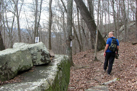
Trail to the Overlook - still below the ladder
The side trails to the Overlook and Sheep Cave were worth the extra effort.
No official trails go to the top of Virgin Falls.
Use care and good judgment at all water crossings and on top of all cliffs.
The Virgin Falls is amazing. The water going over the cliff looks like a bath tub faucet left on and the drain open. The water appears, gushes over the top, and then disappears. It is unique.
Enjoy the area; but tread lightly.
Virgin Falls Trail Mileage
0.00 Scott Gulf Road Trailhead
0.25 Drainage (even if water is not present, it should still be obvious
0.45 Cross Big Branch (half mile marker not far from the crossing)
1.25 Cross Big Branch on rocks - just above Big Branch Falls
1.35 Big Branch Falls
1.50 Cable rigged to aid crossing of Big Laurel Creek
1.65 Overlook Junction
2.30 Big Laurel Falls
3.40 Junction with the Virgin Falls Loop
3.70 Sheep Cave Junction
4.25 Virgin Falls
4.60 Steep rocky ridge
4.80 Return to the end of the Loop Junction
8.20 miles total (3.40 miles to return to the trailhead)
The Sheep Cave side trail adds .15 miles.
The Overlook side trail adds 1.00 mile.
(0.35 to the ladder and 0.15 from the ladder to the Overlook. Total mileage is 0.50 miles one way.)
Text Only - Guide
Virgin Falls Guide (same guide just without the photos for those who just want to carry a description)
Map Link
The link opens in a new window.
Virgin Falls Natural Area Trails - pdf
Virgin Falls Natural Area Trails - geo-pdf
GPS
Control Click or Right Click for download.
Virgin Falls Trails in Text Format - virginfalls.txt
Virgin Falls Trails in GPX Format - virginfalls.gpx
Virgin Falls Trails in KML Format - virginfalls.kml