

Stone Door, Big Creek, Ranger Falls, and Big Creek Rim Trails, page 2
Trail Notes
Parking at the trailhead is very secure. The Rangers lock the gate on the road.
If for some reason you return late to your vehicle, the parking lot is still very secure and the Rangers still lock the gate.
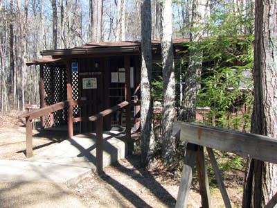
Stone Door Ranger Station
The Ranger Station is a great place to stop for general information about the Natural Area.
The heated restrooms at the trailhead are quite lush!
Water is also available at the trailhead.
Maps of the trail system are available at the trailhead.
Walk-in campsites are available near the trailhead. The sites are a perfect spot for those who like a wilderness setting without having to backpack far.
Picnicking is available at the trailhead.
Most of the trails were easy to follow. A few sections leading through the boulder area below Stone Door were not very trail-like. Look for the blazes.
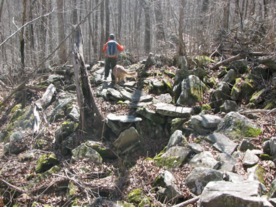
Rocky Trail below the Connector Trail Junction
The Big Creek Gulf and the Big Creek Rim trails both have white blazes.
Trails signs were at every junction.
The area, especially around the Stone Door, sees a lot of use. On our hike we probably saw a number of hikers and campers.
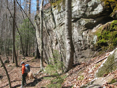
Big Creek Gulf Trail at Overhanding Rock
Never throw rocks off the top of a cliff. We didn’t have trouble with rock throwers, but there were warning signs at the top of Stone Door.
All of the overlooks are exposed. The trail leads next to the cliff’s edge. Keep children in tow.
The Big Creek Gulf Trail makes a few climbs leading away from the creek; but then rejoins it.
We did not see any litter.
There was plenty of water along the trails when we walked them (Feb 2010). I would definitely treat, boil, filter or purify the water.
One of the small creeks on the Big Creek Rim Trail
To access Ranger Falls it is necessary to cross Big Creek. In high water the crossing could be dangerous.
The trail to Ranger Falls follows a dry creek bed. The creek goes into a sink at the falls.
The climb to Alum Gap is steep.
The trails could also be hiked using the Greeter Falls Trailhead.
For an easier hike try the Laurel - Big Creek Rim Trails combination.
There is a register at the trailhead for hikers, climbers, and campers.
Stone Door Trail Mileage
.00 to .25 Paved path from the Stone Door Trailhead to Laurel Gulf Overlook - pavement ends
.25 to .50 Laurel Gulf Overlook to creek
.50 to .80 Creek to Natural Area sign
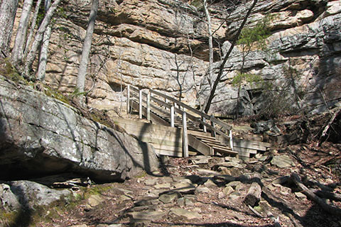
.80 to .90 Natural Area to Stone Door Overlook
Big Creek Gulf Trail Mileage
.00 to .10 Stone Door Overlook to the bottom of the cliffs
.10 to .20 Bottom of the cliff to the left turn, two blazes painted on the rock.
.20 to .30 Left turn across the top of the slab area on rocks - not very trail like
.30 to .90 The slab to the junction with the Connector Trail
.90 to 1.20 Connector Junction to where the trail is near Big Creek
1.20 to 1.30 Trail follows road but leaves starting a climb.
1.30 to 2.00 After climbing for a quarter of a mile and 140 feet elevation, the trail gradually descends and levels to reach the junction with the Ranger Falls Trail
2.00 to 2.30 The trail climbs then levels near Big Rock.
2.30 to 2.50 Trail descends, crosses a creek and adjacent to Overhang Rock, a slightly overhung feature.
2.50 to 2.90 Continuing close to the creek bed the trail begins another climb away from the creek
2.90 to 3.50 Climbing away from the creek, returning to the creek and reaching the roots.
3.50 to 3.90 The spidery root steps, wooden steps, and up an old road to Alum Gap and the Greeter sign
3.90 to 4.00 Greeter sign to Big Creek Rim sign
Big Creek Rim Trail Mileage
.00 to .05 Big Creek Rim sign to campsites
.05 to .50 Campsites to Big Creek Overlook
.50 to .70 Big Creek Overlook to Pine Rock Overlook
.70 to 1.70 Pine Rock Overlook to Sinks Overlook
1.70 to 2.20 Sinks Overlook to rock want-to-be (see picture on page one)
2.20 to 2.95 Rock want-to-be to Split Rock Overlook
2.95 to 3.20 Split Rock to junction with Stone Door Trail
Ranger Falls Trail Mileage
.00 to .10 Leave Big Creek Gulf Trail and follow rocky road/trail to Big Creek
.10 to .20 Cross Big Creek and follow right side of the creek bed to crossing
.20 to .40 Cross the creek bed and continue to the falls
Map Link
The link opens in a new window.
Savage Gulf Stone Door Trailhead Trails - pdf
South Cumberland State Park - Savage Gulf Trails Map - pdf - map of the Natural Area
South Cumberland State Park - Savage Gulf Trails Geo Map - geo-pdf - map of the Natural Area (map may be loaded into a smart phone geo-referenced PDF browser, such as Avenza)
GPS
Control Click or Right Click for download.
Loop Trail in Text Format - sgStoneDoorTr.txt
Loop Trail in GPX Format - sgStoneDoorTr.gpx
Loop Trail in KML Format - sgStoneDoorTr.kml