

North Ridge, Mount Ida - Rocky Mountain National Park
Climb Notes
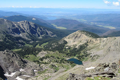
From the summit of Mount Ida, to the south sits Julian Lake and Grand Lake
There are privies at the trailhead, but no water.
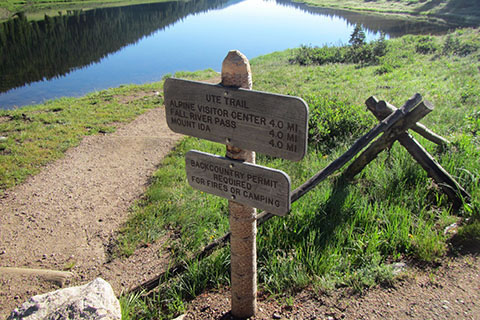
The trail sign at the trailhead incorrectly indicates the distance to Mount Ida as 4.0 miles. It is 4.75 to 5 miles to the summit of Ida from Milner Pass.
Fast acclimated hikers would summit in two hours but the average time for mere mortals would be three to four hours, one way.
The trail/route is popular.
Beware of the weather. Carry appropriate gear. Being on the Continental Divide, it is easy to see clouds approaching. Turn around in threatening weather.
Alpine starts (early morning) are major keys to success in the mountains.
Cairns are built by hikers to help mark their way - sort of like a trail of bread crumbs. The small rock markers are not permanent. They do get knocked over by weather, animals, and other hikers. Do not solely rely on cairns as waypoints. Hopefully, the cairns will lead to where you are going, but they might also lead to a good place to use as a restroom, instead of the summit. You don't know why the cairn trails were built or where they lead. Use good navigation skills to find your destination - cairns are just an aid to navigation.
None of the cairned routes seemed to be shorter or longer, faster or slower.
On the return hike from the summit, stay close to the ridge. The cairns are more difficult to see heading downhill. Do not go down to the left.
Carry a map, digital or paper, and know how to read it.
As you hike turn, to see what the return hike should look like.
We saw ptarmigan, marmots, pika, big horn sheep and a herd of elk on our hike.
For Mountain Data and Route Guide
go to Page
1
North Ridge, Mount Ida Mileage
0.00 Milner Pass Poudre Lake
0.60 Junction with Old Fall River Road
1.40 Rock outcrop
3.40 Saddle between Peak 12,150 and Mount Ida
4.75 Summit of Mount Ida
Note: Mileages may differ, there are many variations to the upper section of the trail but the one way distance should be between 4.75 and 5.25 miles.
Map Link
The link opens in a new window.
Mount Ida and Timber Lake - RMNP - pdf
GPS
Control Click or Right Click for download.
North Ridge, Mount Ida in Text Format - mtIda-n.txt
North Ridge, Mount Ida in GPX Format - mtIda-n.gpx
North Ridge, Mount Ida in KML Format - mtIda-n.kml